Oil and gas production leads to changes in the mass distribution in the subsurface. Hydrocarbon extraction, water flowing in from surrounding aquifers and injection of gas and water alter the mass of fluid present in the rock pores.
Understanding hydrocarbon displacement and drainage throughout a reservoir is the key to higher recovery rates. The most widely spread technology for mapping drainage and fluid substitution is 4D seismic, which involves high costs and significant environmental impact. OCTIO’s gWatch is an alternative to seismic at 10% of the cost and with no impact on marine life.
gWatch measures changes in the gravity field and seafloor subsidence with an accuracy far beyond the reach of any alternative technology. These measurements in turn provide an accurate picture of mass changes and compaction throughout the reservoir. When combined, mass changes and compaction provide a clear picture of the reservoir dynamics, which facilitates optimized infill-well locations and overall production strategy development.
Usual applications of gravity monitoring are:
- Identification of undrained segments as infill-well opportunities
- Prediction of water break-through in wells
- Mapping of aquifer influx, elaboration of mass balances and optimization of drainage strategy
- Quantification of hydrocarbon in place
- Mapping reservoir properties far away from wells (e.g. porosity, compressibility, permeability)
- Insights into reservoir compaction, drilling windows and geomechanical stability, through the accurate measurement of seafloor subsidence
Information obtained from gravity is used to improve reservoir management:
- Infill-well planning: detection of undrained compartments, avoiding water break-through
- Update of hydrocarbon reserves: by adding a quantification of water influx to the balance between produced volumes and reservoir pressure drop
- Improved management of reservations of hydrocarbon transportation means (e.g. pipes)
- Better understanding of reservoir properties far from wells: compressibility, permeability
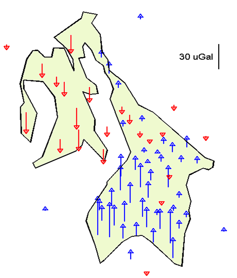
Gravity monitoring yields a very small amount of data: gravity changes at selected positions on the seafloor. Forward-modelling changes in gravity is an unambiguous and straight-forward procedure, which involves summing Newton's law on the volume elements in the reservoir model. In other words: gravity is easy to introduce in any history-matching workflow .
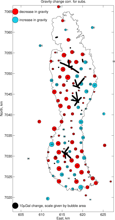
The Ormen Lange field case
Ormen Lange is the second largest gas field in Norway.
Back in 2012, installing compression facilities and drilling infill wells were considered as options to increase gass recovery at Ormen Lange. Two uncertainties needed to be addressed to decide on the optimal strategy, namely water break-through and compartmentalization.
Feasibility studies on a range of monitoring technologies, including seismic and electromagnetic methods, concluded that monitoring 4D gravity and seafloor subsidence would provide the required answers in the most timely manner.
Gravity surveys have been performed over Ormen Lange in 2007, 2009, 2012, 2014, 2016 and 2018.
The conclusions from the operator company are:
- Gravity and subsidence surveys are key for understanding aquifer influx and reservoir compaction
- Gravity provides valuable input to understanding mass changes in the reservoir, with immediate insight into the energy balance of the field
- Gravity can be quickly integrated into history matching workflows